In Minnesota, people talk about the weather – a lot. And in our region, we also talk about the water level of our lakes – a lot. (Hint: They’re related.)
Low or high, local lake dwellers watch their shorelines closely!
It’s no wonder that lake levels are a concern. When water’s high, property owners deal with shore erosion and loss of beach access. When levels are low, residents face lake depths that can be too shallow for larger boats, difficulties at boat launches and docks, and increased exposure to hazards such as submerged rocks.
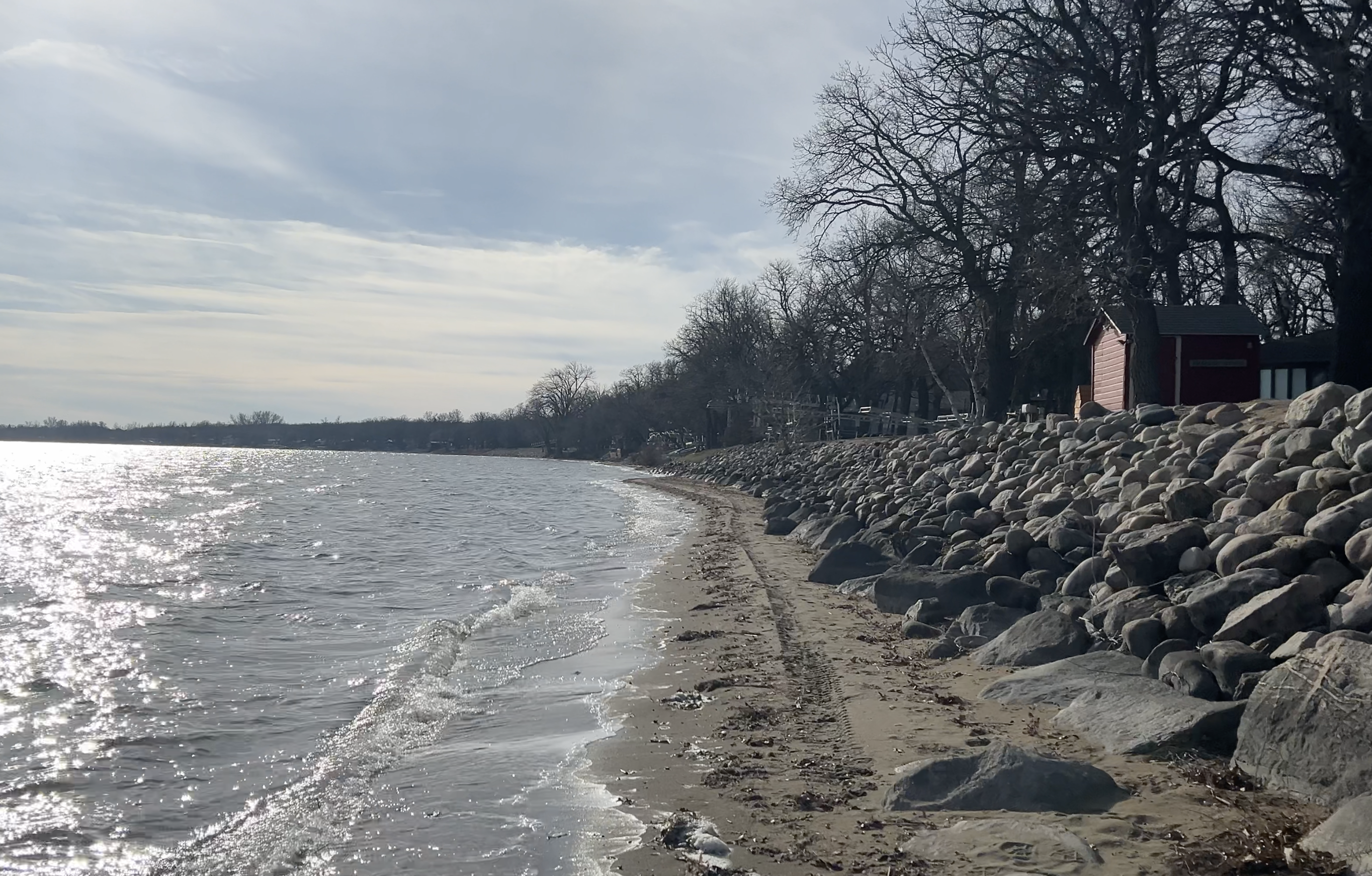
Exposed beach, Otter Tail Lake, November 2023 (Photo: Tom Kuder)
Has it always been this way?
As 2024 begins, we’re in a low water period. With diminished lake levels the past two to three years, there’s a natural amount of concern, conversation – and grumbling – as well as a few misconceptions.
But actually, fluctuating lake levels have been a part of local lake life for decades, as many long-time property owners (and tracking charts) can attest.
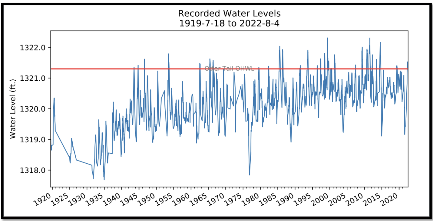
Water levels 1919-2022, Otter Tail Lake (Credit: East Otter Tail Soil and Water Conservation District)
So, why do our lake levels vary so much? It all comes down to two big factors: ecology and meteorology.
Ecology: The Otter Tail River System
Three bodies of water in our Association – Otter Tail Lake, Otter Tail River North, and Deer Lake – are part of the greater Otter Tail River ecosystem.
This system is fed by the Otter Tail River, which starts about 60 miles north of us at Elbow Lake, near Lake Itasca. The river flows south and west to the North Dakota border, passing through more than twenty lakes and reservoirs and gathering more water along the way. From beginning to end, land elevations drop some 500 feet.
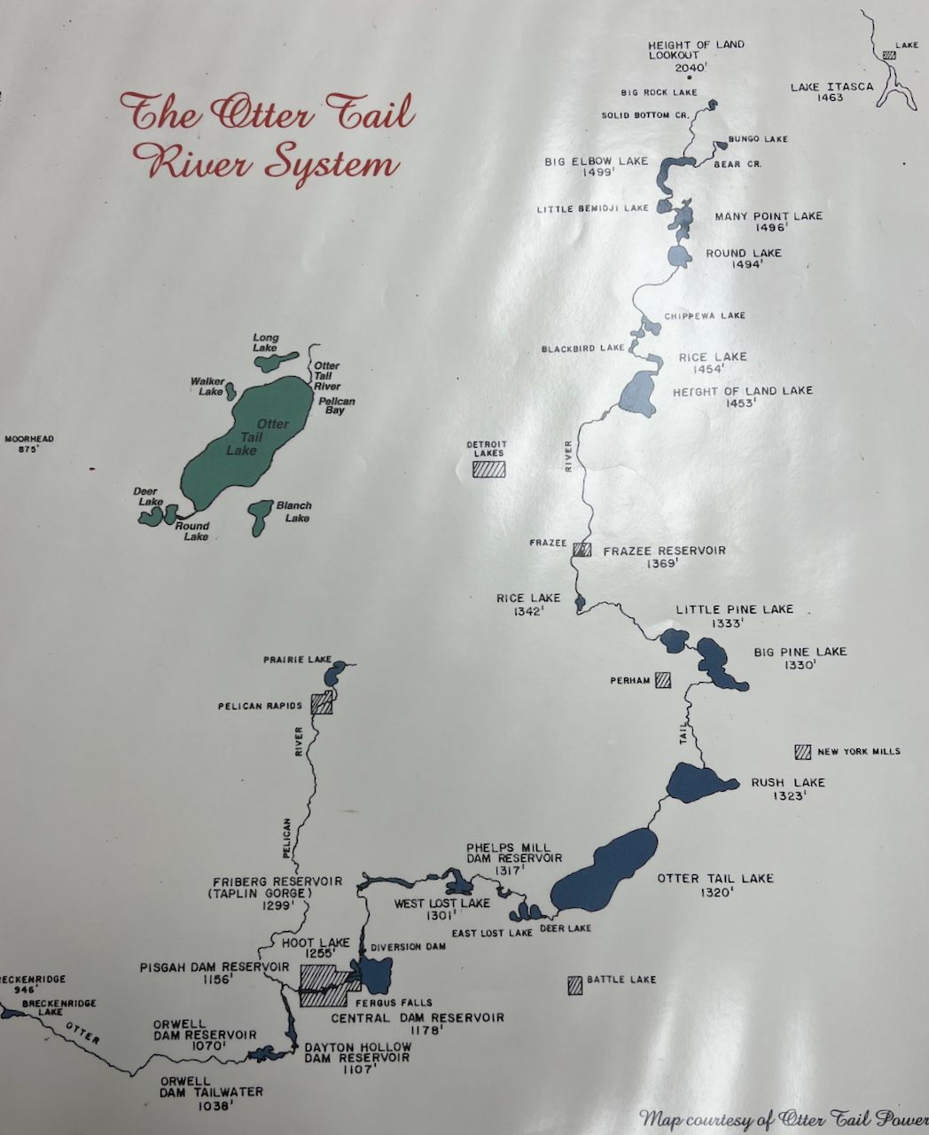
Otter Tail River System (Credit: Otter Tail Power Co.)
Each lake in this chain has a river inflow and an outflow, creating a connected system of water levels. No single lake stands by itself; they’re all impacted by what happens upstream in the watershed.
Changes in water flow
As you might expect, incoming streams and local runoff generally mean that the amount of water flowing out of each lake is greater than the amount flowing in at the Otter Tail River’s inlet. For most lakes in the chain, that’s true. But, surprisingly, it’s not true of Otter Tail Lake, where the outflow is actually significantly less than the inflow. (MN DNR)
How is that even possible? The answer is evaporation.
With nearly 14,000 acres of surface area, Otter Tail Lake experiences some serious evaporation – enough to actually reduce its outflow to less than what entered the lake upstream.
The lake bottom factor
Besides its large surface area, Otter Tail Lake’s unique lake bottom also factors into evaporative water loss. Much of the lake’s structure near shore consists of broad, shallow flats, which warm quickly in the sun and evaporate faster than deeper areas.
These wide, shallow-sloping shorelines (often only two to three feet deep) can visibly exaggerate the effect of dropping water levels, exposing wide stretches of beach in late summer and fall even when water levels drop by only a small amount.
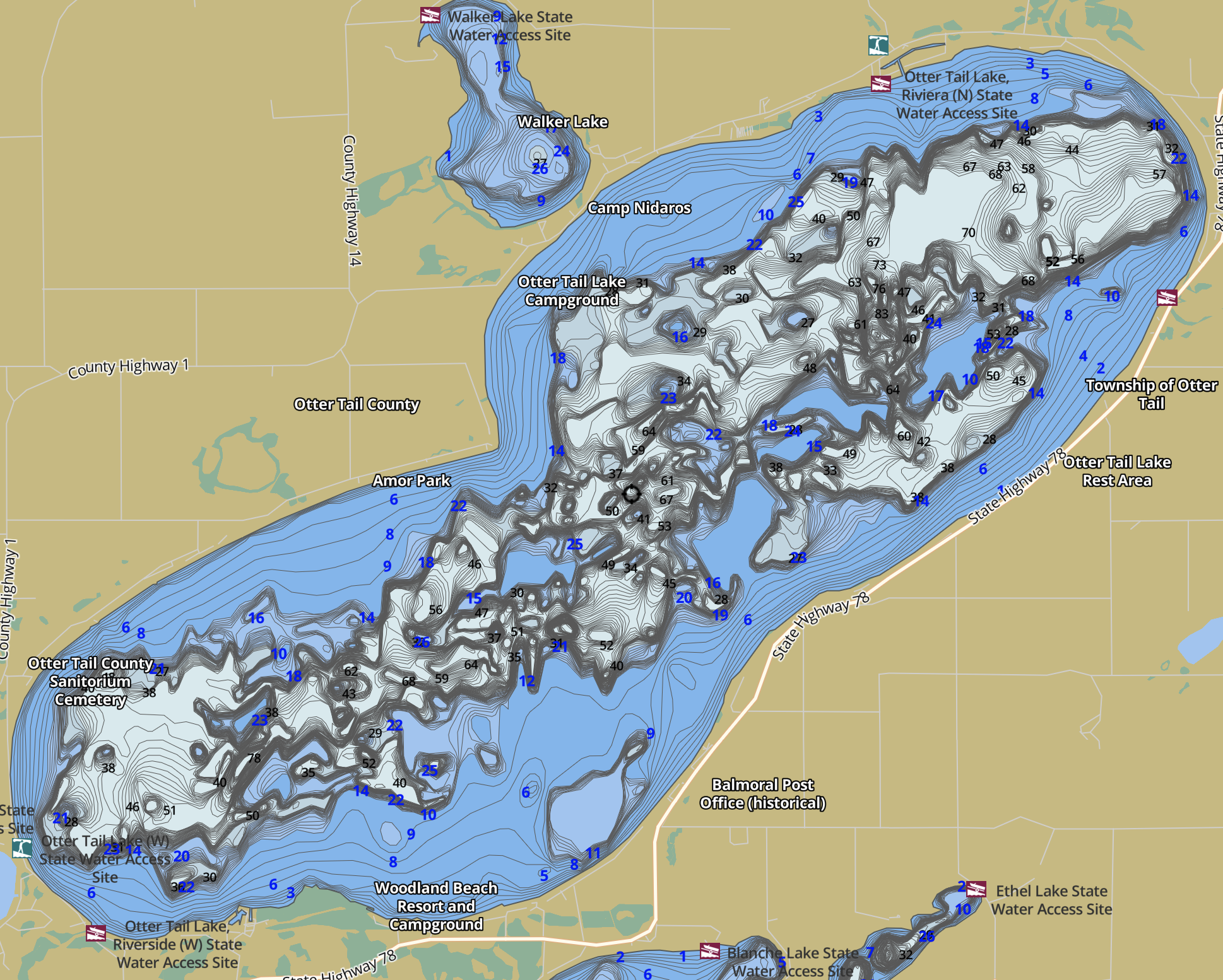
Otter Tail Lake depth map showing shoreline flats (Credit: GPS Nautical Charts)
Meteorology: Precipitation, Temperature, Wind
The unique ecology and structure of our river ecosystem interacts with meteorology – our climate and weather – to determine lake water levels each year.
Precipitation
Annual rain and snow greatly affect the amount of water being added (or lost) across the entire watershed.
In drier years, such as those we’re experiencing now, lake levels along the entire chain drop. In the recent past, Otter Tail Lake saw notable low levels in 1976, 1989, 2004, 2013 and 2021 during periods of low precipitation. With extremely low snowfall this past winter, precipitation is likely to start out at a deficit in 2024.
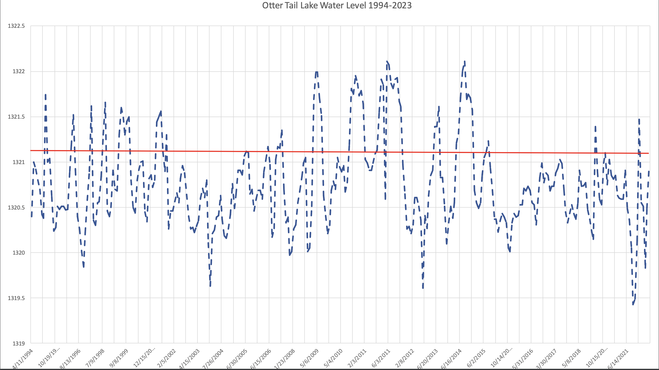
Lake levels 1994-2023, Otter Tail Lake (Source: East Otter Tail Soil and Water Conservation District)
Temperature and wind
To a lesser degree, higher summer temperatures and high winds have an effect on lake levels, too, by accelerating evaporation, particularly on larger waters such as Otter Tail Lake.
Dispelling the Myths
Although fluctuating lake levels have concerned property owners for many generations, and are a direct result of our region’s ecology and meteorology, it’s human nature to wonder if other factors might be at play. Unfortunately, this can result in some misleading myths about how our lake levels – and our lives – are affected.
Myth: Anything Goes On The Lake
Being a lake property owner doesn’t mean that any and all lake uses will be supported by our ecosystem.
Residents years ago experienced the same periodic low water levels as we have in more modern times – but their boats and motors were a lot smaller, so it affected them less. Today’s deep-draft boats and motors with hundreds of horsepower can be fun, but in some years they simply may not be compatible with our variable-level lakes.
Myth: Dams Are At Fault
The Minnesota DNR has installed a number of outlet dams along the Otter Tail River. Each of these dams controls the flow at a set elevation for that lake, called the “Design Runout.” When water is high, more water runs out. When water is low, less outflow occurs.
Some dams have a “Low Flow Opening” to allow a small amount of water to flow even if the lake has dropped below the set level of the dam.
Dams have actually helped smooth out the periodic fluctuations in water levels, while ensuring continued flow for downstream property owners and cities.
Myth: Dam Control Gates Would Be Better
Some earlier models of the DNR dams had gates that could be closed to retain more water. Otter Tail Lake, for example, had a control gate at its outlet until that dam was replaced in 1993.
Unfortunately, retaining more water in one lake by using a control gate, means less water will flow downstream to the next lake. We’re all enjoying the same connected chain of lakes, so who’s to say which lake’s level is more important than another’s?
Myth: The New Rock Ramps Will Empty The Lakes
In 2023, several dams along the Otter Tail River were modified to incorporate rock ramps. The ramps restore natural fish migration, eliminate dangerous safety issues of the Low Flow Openings, and reduce dam maintenance costs. They also look and sound more appealing!
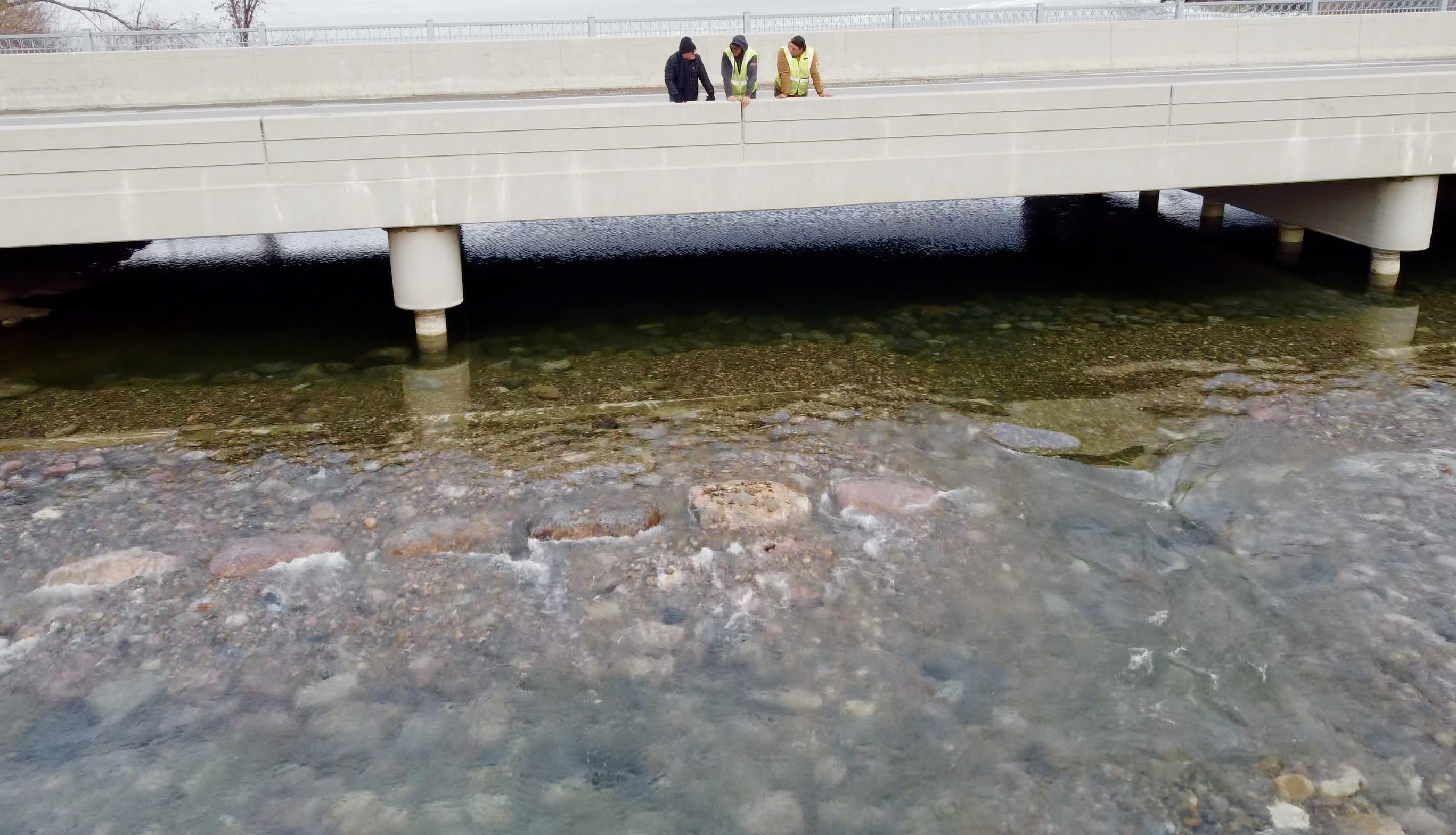
Otter Tail Lake outlet dam and rock ramp, December 2023 (Photo: Tom Kuder)
Some lake residents have wondered if these modifications will be “free flowing,” causing the lakes above them to drain faster. In reality, the ramps were engineered and built with precise GPS and elevation tools to maintain the same flow and level controls of the pre-existing dams. As an example, at the Otter Tail Lake outlet, the bulk of the pre-existing concrete dam is still in place, at the same level as before the rock ramp was installed.
The (Lake) Bottom Line
Fluctuating lake levels are a fact of life in our OTLPOA region.
As with many aspects of lake property ownership, the benefits we enjoy are subject to the influence of the natural world around us. The more we know about how that world operates, the better we can be in tune with it.
The Otter Tail River and its chain of lakes are a vital resource for which we are the current stewards. As we care for this natural asset, let’s celebrate the beauty of the ever-changing waters around us, no matter what their level.